An inspiring space for escape, adventure, discovery and quiet reflection
# Strategic Transport Network
The Peak District National Park is a key tourist destination surrounded by heavily populated urban areas, driving demand for regional connectivity and cross-Park travel. This is facilitated by an extensive road and public transport network, including a network of multi-user trails that support sustainable travel.
# Authorities and plans
The Peak District National Park lies within the boundaries of seven different highway authorities: Derbyshire County Council, Staffordshire County Council, Cheshire East Council, Sheffield City Council, Barnsley Council, Kirklees Council and Oldham Council.
There are six constituent passenger transport authority boundaries and six Local Transport Plans that cover the PDNP. There are also sub-national transport bodies that have emerged in recent years that cover different regional areas. The Peak District falls inside the areas covered by Transport for the North (TfN) and Midlands Connect.
# Connectivity with Local Urban Areas
The Peak District National Park is surrounded by a number of heavily populated urban areas, including Sheffield, Manchester, Derby and Stoke-on-Trent. There has been a longstanding need for connectivity between these urban areas, which has resulted in the current road and rail network crossing the National Park and connecting these cities and the other settlements that surround the National Park.
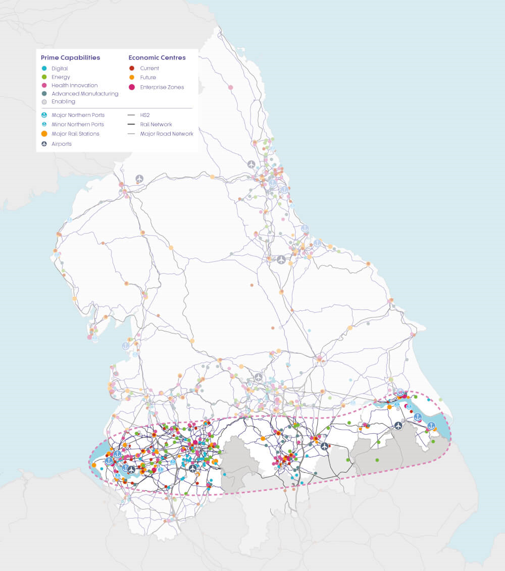
Demand for trans-Pennine travel could increase in the future due to investment in employment and housing either side of the Pennines as well as Transport for the North’s (TfN) promotion of the pan-Northern economy.[1]. This includes TfN’s Strategic Development Corridor crossing the north of the Peak District National Park (see map below).

Transport for the North Strategic Development Corridor Map.
# Active travel network
Active travel refers to making journeys through physically active means, most commonly walking or cycling. The Peak District National Park offers several safe, traffic-free, multi-user routes for leisure and commuting. Additionally, there is an extensive network of public rights of way and large areas of access land that also provide active travel opportunities.
# Public transport network
The National Park has a widespread public transport network. Many areas are covered by bus and coach services. Some are run by commercial operators and some subsidised by local authorities. In addition to traditional bus services, the Peak District also has some demand responsive and community-run services.
Five railway stations on the Hope Valley line are located in the PDNP: Edale, Hope, Bamford, Hathersage and Grindleford. Additionally, a short section of the Trans Pennine railway line passes through a tunnel under the north east edge of the National Park and three other significant railway lines serve the PDNP just outside the boundary: the Buxton, Glossop and Derwent Valley lines. These railway lines have several gateway stations outside the National Park that facilitate access to it: Glossop and Hadfield on the Glossop Line; Buxton, Dove Holes, Chapel-en-le-Frith, Whaley Bridge, New Mills and Disley on the Buxton Line; Matlock, Matlock Bath and Cromford on the Derwent Valley Line; Dore, Chinley and New Mills on the Hope Valley Line; and Marsden, Slaithwaite and Greenfield on the Trans Pennine Line.
# Private motor vehicle network
There are 2,248km of major and minor roads within the Peak District National Park, including 253km of A roads and 124km of B roads.
Many people who travel by private transport into or across the National Park need parking facilities. There are many car parks across the PDNP owned and managed by different landowners. The Peak District National Park Authority owns and manages almost 2,000 car parking spaces across 45 car parks. Over half (27) of these are free to use. Derbyshire Dales District Council has almost 900 car parking spaces in the Peak District across 11 car parks. High Peak Borough Council has just under 300 car parking spaces. There are also many car parking spaces at key visitor attractions such as reservoirs, nature reserves and heritage properties.
What are the gaps in our Research & Data?
- Impact of inter-urban connectivity: Assess the long term value and impact of inter-urban connectivity on the National Park’s special qualities e.g. sustainability, visitor economy benefits and quality of life improvements resulting from enhanced strategic connectivity.
- Understanding and modelling regional connectivity: Produce a comprehensive set of connectivity measures for inter-urban connectivity through the Peak District.
Gov.UK: https://./img.publishing.service.gov.uk/government/uploads/system/uploads/attachment_data/file/600334/South_Pennines_Final.pdf ↩︎