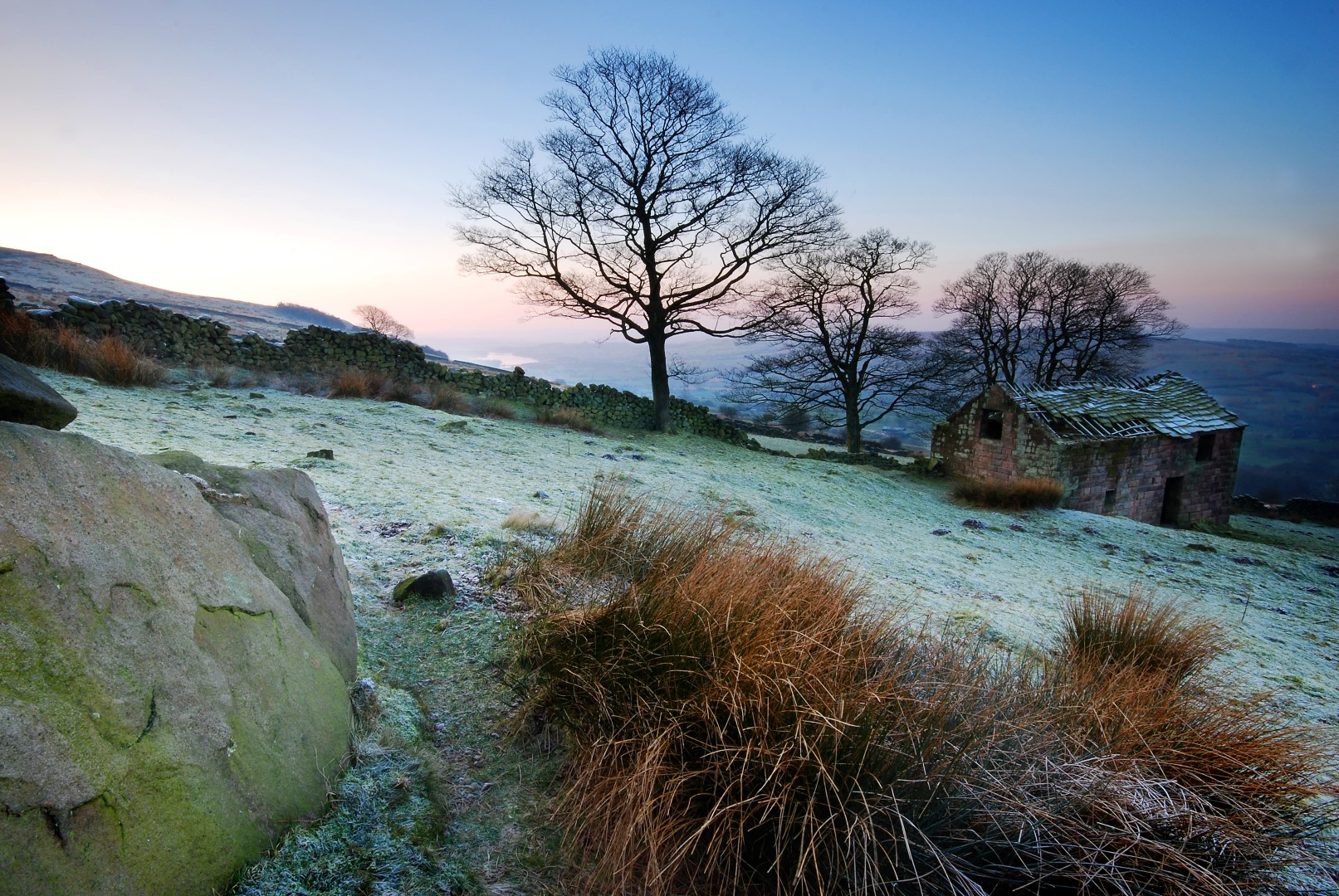
Beautiful views created by contrasting landscapes and dramatic geology
# Landscape and development
The vast majority of new build development is within or on the edge of settlements. In open countryside, re-use of existing buildings is the norm. The ‘natural zone’ retains its wilder, open character.
However, some development that is potentially harmful to these special qualities does take place. In the open countryside, new-build dwellings, agricultural barns and non-land management businesses have been given planning permission contrary to policy (or may be permitted development in the case of agricultural buildings.) There are higher than anticipated levels of development in the natural zone and it is not clear that this contributes to conservation and enhancement.
What are the gaps in our research and data?
We do not currently have enough evidence to judge the cumulative impact on landscape character of all development – whether according to policy or not. The current landscape review or other research will need to address this.
A Policies Map is a plan of the National Park detailing the various proposals and designations referred to in the Local Plan documents. These can be viewed here:
- Policies Map (opens new window) (interactive version)
- Polices Map (opens new window) (legacy version - for reference and printing)
# Applications have been granted contrary to policy
In the previous 8 years, there was only one year where no decisions were made against policy. While this is a worrying trend, the numbers remain low. Each decision made against policy can impact the PDNP special qualities in a multitude of ways. This means quantifying their impact individually or together over time is very difficult. For instance, many of the applications relate to agricultural developments in the open landscape or caravan and camping sites.
General spatial policies (GSPs) provide overarching principles for spatial planning in the National Park and relate closely to the delivery of national park purposes. Policy GSP1 seeks that any development proposal will comply with core policies so that any development in the National Park must satisfy the statutory purposes of national park designation. Where there is an irreconcilable conflict between the statutory purposes, the Sandford Principle will be applied and the conservation of the National Park will be given priority.
Applications granted contrary to the development plan (Strategic policy issues impacting on National Park purposes and special qualities)
| Year | Granted contary to policy | Raised significant policy issues |
|---|---|---|
| 2012-13 | 3 | 3 |
| 2013-14 | 2 | 5 |
| 2014-15 | 4 | 3 |
| 2015-16 | 8 | 3 |
| 2016-17 | 1 | 4 |
| 2017-18 | 0 | 10 |
| 2018-19 | 3 | 5 |
| 2019-20 | 0 | 0 |
| 2020-21 | 0 | 0 |
What are the gaps in our research and data?
Strategic review of permissions made against policy with recommendations for monitoring in the landscape.
# The Natural Zone has protected the PDNP from harmful development
The Natural Zone is part of the spatial strategy and defines areas of wilder and more sensitive landscape and habitat identified under Section 3 of the Wildlife and Countryside Amendment Act 1995. It is defined by:
- a quality of ‘wilderness’
- relatively natural vegetation which is largely self-sown
- few obvious signs of human influence such as field boundaries
- ‘open country’ which has particular importance for certain types of recreation associated with adventure and contact with nature
- high wildlife value
- natural beauty.
There have been a significant number of permissions in the Natural Zone. While the impacts of these permissions are negligible in terms of no new housing or business developments, the Authority will continue to monitor the number and nature of permissions in the Natural Zone carefully owing to the sensitive character of the area.
Applications inside the Natural Zone
| Count of Application Type | 2013 | 2014 | 2015 | 2016 | 2017 | 2018 | 2019 | 2020 | Grand Total |
|---|---|---|---|---|---|---|---|---|---|
| Advertisement Consent | 0 | 1 | 0 | 0 | 0 | 1 | 1 | 0 | 3 |
| Application under the GPDO | 0 | 2 | 0 | 0 | 0 | 1 | 0 | 0 | 3 |
| Discharge of Conditions | 0 | 1 | 0 | 1 | 0 | 0 | 0 | 1 | 3 |
| Full Planning Permission | 4 | 2 | 3 | 7 | 0 | 0 | 0 | 1 | 17 |
| GDO Application extended | 0 | 1 | 0 | 0 | 0 | 0 | 0 | 0 | 1 |
| Listed Building Consent (alter or extend) | 0 | 1 | 0 | 1 | 0 | 0 | 0 | 0 | 2 |
| Non-Material Amendment | 1 | 0 | 0 | 0 | 0 | 0 | 0 | 0 | 1 |
| Telecoms Application (GPDO) | 0 | 2 | 1 | 0 | 1 | 0 | 0 | 0 | 4 |
| Grand Total | 5 | 10 | 4 | 9 | 1 | 2 | 1 | 2 | 34 |
Applications plotted on the PDNPA database GIS are polygons. This data refers to application polygons entirely within the Natural Zone. Some applications may be adjacent to or partially within the Natural Zone (not counted here). Without reviewing each application individually, it is impossible to quantify their impact
What are the gaps in our research and data?
There is insufficient evidence to judge the cumulative impact on landscape character of all development – whether according to policy or not. Further evidence in this regard could be provided by the Landscape Strategy review. If it is not provided by the review (either because of a delay in the review or the methodology) then further research will be needed to assess the impact of development on the landscape.
# Spatial strategy and relationship of settlements
It clear that a significant proportion of development overall does take place outside named settlements. However, the majority of development outside of named settlements is for change of use from farm buildings to holiday, ancillary, agricultural or open market dwellings. There are very few applications for new build dwellings outside of named settlements.
Applications for new build dwellings outside of named settlements
| Year | New Build Dwellings |
|---|---|
| 2012-13 | 3 |
| 2013-14 | 0 |
| 2014-15 | 0 |
| 2015-16 | 2 |
| 2016-17 | 1 |
| 2017-18 | 3 |
| 2018-19 | 6 |
| 2019-20 | 0 |
Whilst a low level of development is anticipated in countryside locations, an over-supply of new development outside named settlements would adversely affect the undeveloped character of the area as well as impacting negatively on the sustainability of the area. It would exacerbate problems for service providers and potentially place more people in remote locations where social interaction and service provision is more difficult, particularly for less mobile members of society, both young and old.
What are the gaps in our research and data?
A broader understanding of development as a whole permitted in the Natural Zone, including natural enhancements as well as built development.
# Landscape development pressures
The majority of development happens in accordance with the spatial strategy. However, as noted in the Local Development Framework Annual Monitoring reports, there are also negative effects on landscape character emerging due to pressure from factors such as:
- development justified on the grounds of supporting agricultural and land management businesses, including large agricultural buildings and infrastructure for grouse shooting
- establishment or expansion of non-land management businesses in the open countryside
- development just outside the boundary of the National Park
- ‘glamping’ sites
- the A628.
There is no evidence either way to say whether the distinctive and valued historic character of the settled, agricultural landscapes of the White Peak have been protected, nor whether the wild character and diversity of more remote areas has been enhanced. There is no evidence either way (particularly with regard to the enhancement of woodland and biodiversity) to say whether the settled, agricultural character of the Derwent Valley landscapes has been protected and managed.
# Agricultural buildings in the PDNP
An analysis of the size and location of new agricultural buildings granted planning permission between 2011 and 2018 has been undertaken. On average, 49 new agricultural buildings per year were permitted across the National Park. 62% of these were in the White Peak, 30% in the South-West Peak and 8% in the Dark Peak. The average size of the buildings permitted is 334m² (equivalent to approximately a 20m x 17m building).

Chris Gilbert.
Of the new agricultural buildings built during the seven year period, 24% were applications under the General Permitted Development Order (GPDOs) and 76% were full planning applications. The GPDOs averaged a size of 244m² and the full applications averaged a size of 363m².
The report also considers the effect of new agricultural buildings on valued landscape character (and by implication the effectiveness of existing planning policy). Although limited to using only plans and aerial photography, the report concludes that ‘the majority are within farmsteads and appear appropriate’. However, some development appears to be contrary to policy and cumulatively could be causing harm to the landscape, such as:
- buildings that are divorced from the farm
- substantial yard areas and access tracks even on relatively small buildings
- buildings within green fields
- buildings that are overly large
- loss of cultural heritage features.
What are the gaps in our research and data?
More research is needed to understand landscape impact, in particular to improve mapping (where are the hotspots) and undertake site visits to quantify the impact on the surrounding landscape.
# Electricity infrastructure
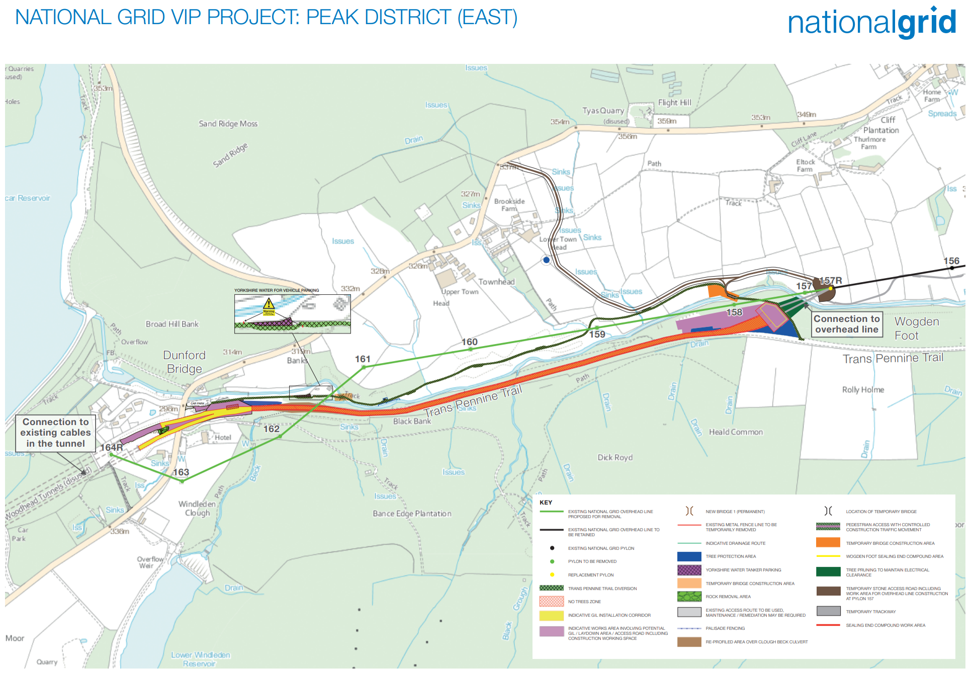
Pylons in the Peak District National Park have been dominating the skyline in the Longdendale Valley since the 1960s, with a notable impact on the natural beauty of the area. However, the Peak District National Park (East) project will replace a 2km section of overhead line east of the Woodhead Tunnel near Dunford Bridge with an underground connection, permanently removing seven pylons and a sealing end compound from the landscape [1].

The preferred route for the connection runs along the Trans Pennine Trail to the south of the River Don to join the existing cables in the Woodhead Tunnel. To connect the remaining existing overhead line, a sealing end compound and associated terminal pylon would need to be constructed at Wogden Foot.
National Grid supply shapefiles of ‘high voltage overhead electricity lines’. Note that only the high voltage ones are included, not any local lines, and the data only covers England and Wales.
Map showing the distribution of UK Grid 400kv through the Peak District including the section above to be undergrounded [2]
# Telecoms Infrastructure
Broadband is a very fast-moving and complex topic and so it is difficult to predict the outcome of government and community investment over the next 2 to 3 years. There remains uncertainty over funding processes, technology and commercial sensitivity of data and there may be planning considerations as a result of any wireless infrastructure. It is worth noting that the Peak District National Park Authority have worked with mobile phone companies in the past to approve over 90% of masts in the PDNP.
For more information on broadband see the local economy section.
What are the gaps in our research and data?
- Extract data from OS MasterMap or OS Vector for all overhead (any voltage) powerlines in the PDNP
- Viewshed analysis of wind turbine location for turbines greater than 15 meters.